
Carte topographique Sucre
Carte interactive
Cliquez sur la carte pour afficher l’altitude.
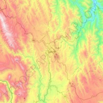
Carte topographique Sucre, altitude, relief
Sucre
Sucre (Spanish: [ˈsukɾe]) is the de jure capital city of Bolivia, the capital of the Chuquisaca Department and the sixth most populous city in Bolivia. Located in the south-central part of the country, Sucre lies at an elevation of 2,790 m (9,150 ft). This relatively high altitude gives the city a subtropical highland climate with cool temperatures year-round.
À propos de cette carte
Nom : Carte topographique Sucre, altitude, relief.
Altitude moyenne : 2 829 m
Altitude minimum : 1 882 m
Altitude maximum : 3 846 m