
Carte topographique Mombasa
Carte interactive
Cliquez sur la carte pour afficher l’altitude.
Mombasa
Being a coastal town, Mombasa is characterised by a flat topography. The town of Mombasa is centred on Mombasa Island, but extends to the mainland. The island is separated from the mainland by two creeks, Port Reitz in the south and Tudor Creek in the north.
À propos de cette carte
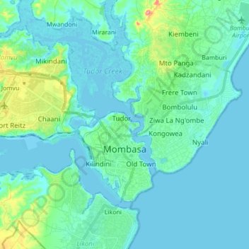
Nom : Carte topographique Mombasa, altitude, relief.
Lieu : Mombasa, Coastal Kenya, Kenya (-4.08098 39.59569 -3.99304 39.73303)
Altitude moyenne : 18 m
Altitude minimum : -3 m
Altitude maximum : 118 m