
Carte topographique Pelotas
Carte interactive
Cliquez sur la carte pour afficher l’altitude.
Pelotas
As it is situated on a plain near the ocean, the urban area lies on a low elevation, being, on average, 7 meters (23 ft) above sea level. The interior of the municipality is on a plateau called Serras de Sudeste (Southeastern Mountain Ranges). Consequently, the altitude in Pelotas' rural area reaches 429 meters (1,407.4 ft) in the Quilombo district.
À propos de cette carte
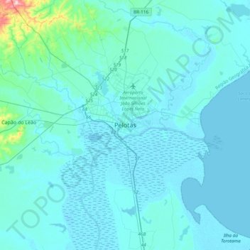
Nom : Carte topographique Pelotas, altitude, relief.
Altitude moyenne : 18 m
Altitude minimum : -2 m
Altitude maximum : 287 m