
Carte topographique Austin
Carte interactive
Cliquez sur la carte pour afficher l’altitude.
À propos de cette carte
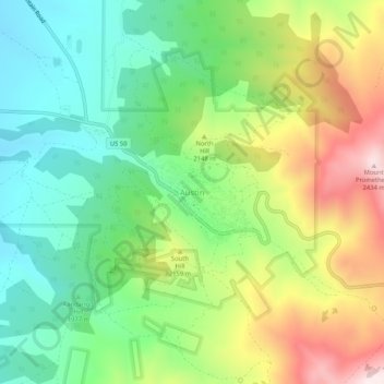
Nom : Carte topographique Austin, altitude, relief.
Lieu : Austin, Lander County, Nevada, United States (39.47326 -117.08954 39.51326 -117.04954)
Altitude moyenne : 2 076 m
Altitude minimum : 1 841 m
Altitude maximum : 2 464 m
Austin is an unincorporated small town in, and former county seat of, Lander County, Nevada, United States. In 2020, the census-designated place of Austin had a population of 167. It is located on the western slopes of the Toiyabe Range at an elevation of 6,575 feet (2,004 m). U.S. Route 50 passes through the town.
Autres cartes topographiques
Cliquez sur une carte pour visualiser sa topographie, son altitude et son relief.
Kingston
United States > Nevada > Lander County
Kingston, Lander County, Nevada, United States
Altitude moyenne : 1 964 m
Battle Mountain
United States > Nevada > Lander County
Battle Mountain, Lander County, Nevada, United States
Altitude moyenne : 1 376 m