
Carte topographique El Bayadh
Carte interactive
Cliquez sur la carte pour afficher l’altitude.
À propos de cette carte
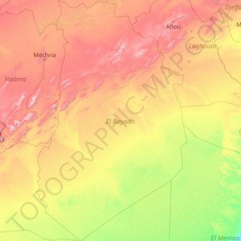
Nom : Carte topographique El Bayadh, altitude, relief.
Lieu : El Bayadh, RADP (30.70166 -0.41587 34.44817 2.36031)
Altitude moyenne : 852 m
Altitude minimum : 370 m
Altitude maximum : 2 173 m
Autres cartes topographiques
Cliquez sur une carte pour visualiser sa topographie, son altitude et son relief.
El Abiodh Sidi Cheikh
RADP > El Bayadh > El Abiodh Sidi Cheikh
El Abiodh Sidi Cheikh, daïra El Abiodh Sidi Cheikh, El Bayadh, 32003, RADP
Altitude moyenne : 776 m