
Carte topographique Bury St Edmunds
Carte interactive
Cliquez sur la carte pour afficher l’altitude.
Bury St Edmunds
The name Bury is etymologically connected with borough, which has cognates in other Germanic languages such as the German burg meaning "fortress, castle"; Old Norse borg meaning "wall, castle"; and Gothic baurgs meaning "city". They all derive from Proto-Germanic *burgs meaning "fortress". This in turn derives from the Proto-Indo-European root *bhrgh meaning "fortified elevation", with cognates including Welsh bera ("stack") and Sanskrit bhrant- ("high, elevated building").
À propos de cette carte
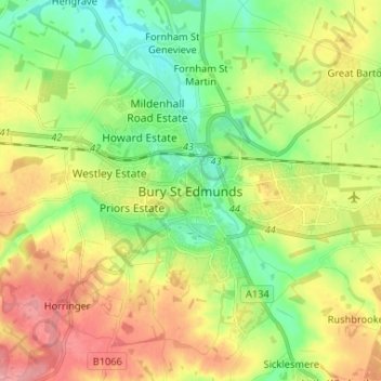
Nom : Carte topographique Bury St Edmunds, altitude, relief.
Altitude moyenne : 59 m
Altitude minimum : 21 m
Altitude maximum : 107 m