
Carte topographique Sawtooth Mountains
Carte interactive
Cliquez sur la carte pour afficher l’altitude.
À propos de cette carte
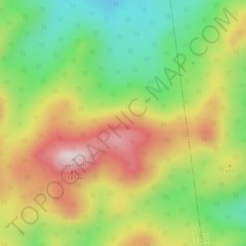
Nom : Carte topographique Sawtooth Mountains, altitude, relief.
Lieu : Sawtooth Mountains, Franklin County, New York, USA (44.19278 -74.11354 44.19288 -74.11344)
Altitude moyenne : 927 m
Altitude minimum : 722 m
Altitude maximum : 1 168 m
Autres cartes topographiques
Cliquez sur une carte pour visualiser sa topographie, son altitude et son relief.
Beachville
USA > New York > Beachville
Beachville, Steuben County, New York, USA
Altitude moyenne : 555 m
Cumminsville
USA > New York > Cumminsville
Cumminsville, North Dansville Town, Livingston County, New York, 14437, USA
Altitude moyenne : 238 m
Jordan River
Jordan River, Saint Lawrence County, New York, USA
Altitude moyenne : 479 m
Big Bear Mountain
Big Bear Mountain, Town of Johnsburg, Warren County, New York, USA
Altitude moyenne : 616 m
Roosevelt Island
USA > New York > New York City
Roosevelt Island, Manhattan Community Board 8, New York County, New York City, New York, 10044, USA
Altitude moyenne : 13 m
Lake Georgina
Lake Georgina, Lake Georgina Road, Woodbury, Town of Woodbury, Orange County, New York, 10930, USA
Altitude moyenne : 290 m
Flat Top Mountain
Flat Top Mountain, Franklin County, New York, USA
Altitude moyenne : 568 m
Lake Cecil
Lake Cecil, Lake Cecil Road, Tacoma, Town of Masonville, Delaware County, New York, 13847, USA
Altitude moyenne : 518 m
Mount Warren
Mount Warren, Town of Bovina, Delaware County, New York, USA
Altitude moyenne : 677 m
Hen and Chicken Islands
Hen and Chicken Islands, Town of Long Lake, Hamilton County, New York, 13436, USA
Altitude moyenne : 606 m
Black Lake
USA > New York > Black Lake
Black Lake, Town of Bethel, Sullivan County, New York, 12720, USA
Altitude moyenne : 391 m