
Carte topographique Samnaun
Carte interactive
Cliquez sur la carte pour afficher l’altitude.
Samnaun
Until 2017 it was part of the Ramosch sub-district, of the Inn district, after 2017 it was part of the Engiadina Bassa/Val Müstair Region. It is located in a left side valley of the Engadin valley, at an elevation of 1,700–1,840 meters (5,580–6,040 ft). It consists of five village sections; Compatsch, Laret, Plan (Plaun), Ravaisch and Samnaun.
À propos de cette carte
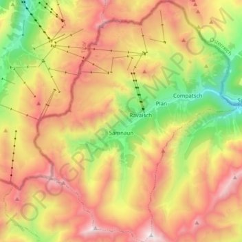
Nom : Carte topographique Samnaun, altitude, relief.
Altitude moyenne : 2 369 m
Altitude minimum : 1 481 m
Altitude maximum : 3 262 m