
Carte topographique Addison (Webster Springs)
Carte interactive
Cliquez sur la carte pour afficher l’altitude.
À propos de cette carte
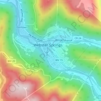
Nom : Carte topographique Addison (Webster Springs), altitude, relief.
Altitude moyenne : 602 m
Altitude minimum : 431 m
Altitude maximum : 878 m
Webster Springs is located at 38°28′34″N 80°24′36″W / 38.47611°N 80.41000°W / 38.47611; -80.41000 (38.476192, -80.410025), along the Elk River. According to the United States Census Bureau, the town has a total area of 0.47 square miles (1.22 km2), of which 0.45 square miles (1.17 km2) is land and 0.02 square miles (0.05 km2) is water. It lies at an elevation of 1,460 ft. (445m) and is close to Buffalo Bull Knob, elevation 2,799 ft.
Autres cartes topographiques
Cliquez sur une carte pour visualiser sa topographie, son altitude et son relief.
Diana
United States > West Virginia > Webster County
Diana, Webster County, West Virginia, 26217, United States
Altitude moyenne : 553 m
Hacker Valley
United States > West Virginia > Webster County
Hacker Valley, Webster County, West Virginia, 26222, United States
Altitude moyenne : 582 m
Cowen
United States > West Virginia > Webster County
Cowen, Webster County, West Virginia, 26206, United States
Altitude moyenne : 709 m
Holly River State Park
United States > West Virginia > Webster County
Holly River State Park, Webster County, West Virginia, United States
Altitude moyenne : 674 m
Big Ditch Lake
United States > West Virginia > Webster County
Big Ditch Lake, Webster County, West Virginia, United States
Altitude moyenne : 708 m