
Faire un don
Équipez-vous pour votre prochaine aventure :
En tant que Partenaire Amazon, ce site perçoit une commission sur les achats éligibles sans surcoût pour vous.
Carte topographique Ilam Province
Cliquez sur la carte pour afficher l’altitude.
Faire un don
Équipez-vous pour votre prochaine aventure :
En tant que Partenaire Amazon, ce site perçoit une commission sur les achats éligibles sans surcoût pour vous.
Ilam Province
Contrary to the north, the south and southwestern part of the province is covered with low-lying plains with elevation varying between 50 and 300 m (160 and 980 ft) above sea level. Despite receiving little precipitation, large areas of these low lands, notably Dehloran, Musian and Dasht Abbas, are cultivated owing to a combination of factors such as rivers flowing from the mountains to the east, dams and irrigation networks.
Faire un don
Équipez-vous pour votre prochaine aventure :
En tant que Partenaire Amazon, ce site perçoit une commission sur les achats éligibles sans surcoût pour vous.
À propos de cette carte
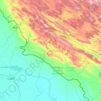
Nom : Carte topographique Ilam Province, altitude, relief.
Lieu : Ilam Province, Iran (32.04852 45.69252 34.03770 48.03564)
Altitude moyenne : 630 m
Altitude minimum : 4 m
Altitude maximum : 2 803 m
Faire un don
Équipez-vous pour votre prochaine aventure :
En tant que Partenaire Amazon, ce site perçoit une commission sur les achats éligibles sans surcoût pour vous.
Autres cartes topographiques
Cliquez sur une carte pour visualiser sa topographie, son altitude et son relief.
Zagros Mountains
Iran > Isfahan Province > Semirom County > Padena-ye Vosta RD
Altitude moyenne : 3 846 m
Faire un don
Équipez-vous pour votre prochaine aventure :
En tant que Partenaire Amazon, ce site perçoit une commission sur les achats éligibles sans surcoût pour vous.
Zagros Mountains
Iran > Isfahan Province > Semirom County > Padena-ye Vosta RD
Altitude moyenne : 3 846 m
Khatunabad
Iran > Kerman Province > Shahr-e-Babak County > دهستان خاتون آباد
Altitude moyenne : 1 851 m
Faire un don
Équipez-vous pour votre prochaine aventure :
En tant que Partenaire Amazon, ce site perçoit une commission sur les achats éligibles sans surcoût pour vous.
Faire un don
Équipez-vous pour votre prochaine aventure :
En tant que Partenaire Amazon, ce site perçoit une commission sur les achats éligibles sans surcoût pour vous.
Minoo Island
Iran > Khuzestan Province > Khoramshahr County > دهستان جزیره مینو
Altitude moyenne : 2 m
قلعه گبری (ایرج)
Iran > Tehran Province > Pishva County > Asgariyeh RD > عسگرآباد عباسی > قلعه گبری
Altitude moyenne : 944 m
Faire un don
Équipez-vous pour votre prochaine aventure :
En tant que Partenaire Amazon, ce site perçoit une commission sur les achats éligibles sans surcoût pour vous.
Kharvana
Iran > East Azerbaijan Province > Varzaqan County > دهستان دیزمارمرکزی
Altitude moyenne : 1 489 m
Faire un don
Équipez-vous pour votre prochaine aventure :
En tant que Partenaire Amazon, ce site perçoit une commission sur les achats éligibles sans surcoût pour vous.
علویان
Iran > East Azerbaijan Province > Maragheh County > دهستان سراجوی غربی
Altitude moyenne : 1 551 m
Malek Abad
Iran > Sistan and Baluchestan Province > Zahedan County > دهستان حرمک
Altitude moyenne : 957 m
Faire un don
Équipez-vous pour votre prochaine aventure :
En tant que Partenaire Amazon, ce site perçoit une commission sur les achats éligibles sans surcoût pour vous.
Malekabad
Iran > Lorestan Province > Delfan County > دهستان میربگ شمالی > Cheraghabad
Altitude moyenne : 1 797 m
Faire un don
Équipez-vous pour votre prochaine aventure :
En tant que Partenaire Amazon, ce site perçoit une commission sur les achats éligibles sans surcoût pour vous.
جاده میانکاله
Iran > Golestan Province > Torkaman County > South Chaparbay District > آشوراده
Altitude moyenne : -27 m
Faire un don
Équipez-vous pour votre prochaine aventure :
En tant que Partenaire Amazon, ce site perçoit une commission sur les achats éligibles sans surcoût pour vous.
Faire un don
Équipez-vous pour votre prochaine aventure :
En tant que Partenaire Amazon, ce site perçoit une commission sur les achats éligibles sans surcoût pour vous.
Faire un don
Équipez-vous pour votre prochaine aventure :
En tant que Partenaire Amazon, ce site perçoit une commission sur les achats éligibles sans surcoût pour vous.
Faire un don
Équipez-vous pour votre prochaine aventure :
En tant que Partenaire Amazon, ce site perçoit une commission sur les achats éligibles sans surcoût pour vous.
Iranian plateau
Iran > South Khorasan Province > Tabas County > دهستان دیهوک
The northwestern Iranian plateau, where the Pontic and Taurus Mountains converge, is rugged country with higher elevations, a more severe climate, and greater precipitation than are found on the Anatolian plateau. The region is known as the Anti-Taurus, and the average elevation of its peaks exceeds 3,000 m…
Altitude moyenne : 1 061 m
Damavand
Iran > Mazandaran Province > Amol County > دهستان لاریجان سفلی
Mount Damavand (Persian: دماوند [dæmɒːˈvænd] English: /dɔːmoʊˈvænd/ Da-moh-VAND) is a dormant stratovolcano in Iran. It is the highest peak in Iran and Western Asia, the highest volcano in Asia, and the 3rd highest volcano in the Eastern Hemisphere (after Mount Kilimanjaro and Mount Elbrus), at…
Altitude moyenne : 4 949 m
Faire un don
Équipez-vous pour votre prochaine aventure :
En tant que Partenaire Amazon, ce site perçoit une commission sur les achats éligibles sans surcoût pour vous.
Faire un don
Équipez-vous pour votre prochaine aventure :
En tant que Partenaire Amazon, ce site perçoit une commission sur les achats éligibles sans surcoût pour vous.
Faire un don
Équipez-vous pour votre prochaine aventure :
En tant que Partenaire Amazon, ce site perçoit une commission sur les achats éligibles sans surcoût pour vous.
Alborz Mountains
Iran > Mazandaran Province > Amol County > دهستان لاریجان سفلی
While the southern slopes of the Alborz Mountains are usually semiarid or arid, with irregular and low precipitation, the northern slopes of the range are usually humid, especially in the western parts of the Central Alborz. The Alborz is the easternmost extent of many European plant species. In the southern…
Altitude moyenne : 4 934 m
Faire un don
Équipez-vous pour votre prochaine aventure :
En tant que Partenaire Amazon, ce site perçoit une commission sur les achats éligibles sans surcoût pour vous.
Band-e Amir
Iran > Fars Province > Zarghan County > Band-e Amir Rural District
Altitude moyenne : 1 598 m
Faire un don
Équipez-vous pour votre prochaine aventure :
En tant que Partenaire Amazon, ce site perçoit une commission sur les achats éligibles sans surcoût pour vous.
Damavand
Iran > Mazandaran Province > Amol County > دهستان لاریجان سفلی
Mount Damavand (Persian: دماوند [dæmɒːvænd] ) is a dormant stratovolcano and is the highest peak in Iran and Western Asia, the highest volcano in Asia, and the 3rd highest volcano in the Eastern Hemisphere (after Mount Kilimanjaro and Mount Elbrus), at an elevation of 5,609 metres (18,402 ft).…
Altitude moyenne : 4 949 m
Faire un don
Équipez-vous pour votre prochaine aventure :
En tant que Partenaire Amazon, ce site perçoit une commission sur les achats éligibles sans surcoût pour vous.
چاه حسن کهوری
Iran > Hormozgan Province > Bandar-e-Abbas County > دهستان ایسین
Altitude moyenne : 148 m
Soltanabad-e Tanbali
Iran > Kurdistan Province > Bijar County > دهستان نجف آباد
Altitude moyenne : 2 027 m
Faire un don
Équipez-vous pour votre prochaine aventure :
En tant que Partenaire Amazon, ce site perçoit une commission sur les achats éligibles sans surcoût pour vous.
Faire un don
Équipez-vous pour votre prochaine aventure :
En tant que Partenaire Amazon, ce site perçoit une commission sur les achats éligibles sans surcoût pour vous.
Kaleybar
Iran > East Azerbaijan Province > Kaleybar County > دهستان ییلاق
The relatively well preserved Babak Castle at an altitude of 2300 m is located is located some 3 km of the town. This Sasanid era fortress is named after the ninth century Iranian resistance leader, Babak Khorramdin., who resisted Arab armies until year 839.
Altitude moyenne : 1 457 m
Gold
Iran > Chaharmahal and Bakhtiyari Province > Lordegan County > Sardasht Rural District
Altitude moyenne : 1 739 m
Faire un don
Équipez-vous pour votre prochaine aventure :
En tant que Partenaire Amazon, ce site perçoit une commission sur les achats éligibles sans surcoût pour vous.
Bijar
Iran > Kurdistan Province > Bijar County > بیجار
With an elevation of 1,940 metres, Bijar has been called the Roof of Iran.
Altitude moyenne : 2 012 m
Taftan
Iran > Sistan and Baluchestan Province > Mirjaveh County > دهستان تمین
Taftan is the highest mountain in southeast Iran. The topography is overall steep. Deep valleys with U and V shapes have developed on Taftan, and the volcano has a strongly eroded appearance. One of these valleys, Tamindan, may be the Damindan valley in the Avesta religious texts. One series of ignimbrites…
Altitude moyenne : 3 525 m
Faire un don
Équipez-vous pour votre prochaine aventure :
En tant que Partenaire Amazon, ce site perçoit une commission sur les achats éligibles sans surcoût pour vous.
Mozdooran Cave
Iran > Razavi Khorasan > Sarakhs County > دهستان مرزداران > Mazdavand
Altitude moyenne : 976 m
Faire un don
Équipez-vous pour votre prochaine aventure :
En tant que Partenaire Amazon, ce site perçoit une commission sur les achats éligibles sans surcoût pour vous.
Khalifan, Mahabad
Iran > West Azerbaijan Province > Mahabad County > دهستان کانی بازار
Altitude moyenne : 1 558 m
Faire un don
Équipez-vous pour votre prochaine aventure :
En tant que Partenaire Amazon, ce site perçoit une commission sur les achats éligibles sans surcoût pour vous.
Faire un don
Équipez-vous pour votre prochaine aventure :
En tant que Partenaire Amazon, ce site perçoit une commission sur les achats éligibles sans surcoût pour vous.
East Azarbaijan
The highest point in East Azerbaijan is the volcanic peak of Sahand Mountain at 3,707 m (12,162 ft) of elevation, lying south of Tabriz, whereas the lower-lying areas are around Garmadooz (Ahar). The hills and mountains of the province are divided into three ranges: the Qara Daq Mountains, the Sahand and…
Altitude moyenne : 1 249 m
Faire un don
Équipez-vous pour votre prochaine aventure :
En tant que Partenaire Amazon, ce site perçoit une commission sur les achats éligibles sans surcoût pour vous.