
Carte topographique Borough of Copeland
Carte interactive
Cliquez sur la carte pour afficher l’altitude.
À propos de cette carte
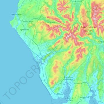
Nom : Carte topographique Borough of Copeland, altitude, relief.
Lieu : Borough of Copeland, Cumbria, England, United Kingdom (54.16784 -3.64062 54.60734 -3.11414)
Altitude moyenne : 156 m
Altitude minimum : 0 m
Altitude maximum : 962 m
Autres cartes topographiques
Cliquez sur une carte pour visualiser sa topographie, son altitude et son relief.
Knock
United Kingdom > England > Cumbria
Knock, Long Marton, Cumbria, England, CA16 6DH, United Kingdom
Altitude moyenne : 227 m
Coniston
United Kingdom > England > Cumbria > South Lakeland
Coniston, South Lakeland, Cumbria, England, United Kingdom
Altitude moyenne : 282 m
Borrowdale
United Kingdom > England > Cumbria > Allerdale
Borrowdale, Allerdale, Cumbria, England, United Kingdom
Altitude moyenne : 384 m
Windermere
United Kingdom > England > Cumbria > South Lakeland
Windermere, South Lakeland, Cumbria, England, LA23 1AB, United Kingdom
Altitude moyenne : 147 m
Scafell Pike
United Kingdom > England > Cumbria > Borough of Copeland
Scafell Pike, Borough of Copeland, Cumbria, England, CA20 1EX, United Kingdom
Altitude moyenne : 679 m