
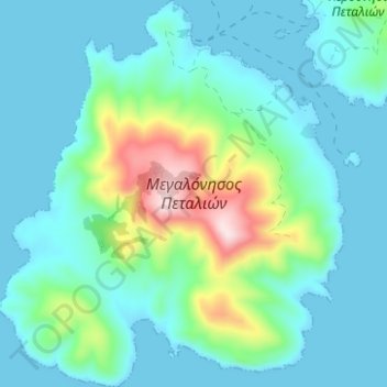
Carte topographique Megalos Petalios
Carte interactive
Cliquez sur la carte pour afficher l’altitude.
À propos de cette carte
Nom : Carte topographique Megalos Petalios, altitude, relief.
Altitude moyenne : 71 m
Altitude minimum : 0 m
Altitude maximum : 368 m
Autres cartes topographiques
Cliquez sur une carte pour visualiser sa topographie, son altitude et son relief.
Skyros
Greece > Thessaly - Central Greece
Skyros, Δήμος Σκύρου, Regional Unit of Euboea, Region of Central Greece, Thessaly - Central Greece, 34007, Greece
Altitude moyenne : 61 m
Malakasi
Greece > Thessaly - Central Greece > Malakasi
Malakasi, Kalampaka Municipality, Regional Unit of Trikala, Region of Thessaly, Thessaly - Central Greece, 42200, Greece
Altitude moyenne : 971 m
Stomio
Greece > Thessaly - Central Greece > Stomio
Stomio, Agia Municipality, Regional Unit of Larisa, Region of Thessaly, Thessaly - Central Greece, 40007, Greece
Altitude moyenne : 102 m
Trikala
Greece > Thessaly - Central Greece > Trikala
Trikala, Trikala Municipality, Regional Unit of Trikala, Region of Thessaly, Thessaly - Central Greece, 42100, Greece
Altitude moyenne : 247 m
Κοινότητα Δελφών
Greece > Thessaly - Central Greece > Delphi
Κοινότητα Δελφών, Delphi, Δήμος Δελφών, Regional Unit of Phocis, Region of Central Greece, Thessaly - Central Greece, 33054, Greece
Altitude moyenne : 598 m
Anthousa
Greece > Thessaly - Central Greece > Anthousa
Anthousa, Kalampaka Municipality, Regional Unit of Trikala, Region of Thessaly, Thessaly - Central Greece, 42036, Greece
Altitude moyenne : 1 290 m
Pindus
Greece > Thessaly - Central Greece
Pindus, Δήμος Αργιθέας, Karditsa Regional Unit, Region of Thessaly, Thessaly - Central Greece, Greece
Altitude moyenne : 1 510 m