
Carte topographique Antioch
Carte interactive
Cliquez sur la carte pour afficher l’altitude.
À propos de cette carte
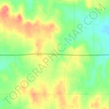
Nom : Carte topographique Antioch, altitude, relief.
Lieu : Antioch, Marshall County, Oklahoma, United States (34.08010 -96.84834 34.12010 -96.80834)
Altitude moyenne : 269 m
Altitude minimum : 241 m
Altitude maximum : 296 m
Autres cartes topographiques
Cliquez sur une carte pour visualiser sa topographie, son altitude et son relief.
Lake Texoma
United States > Oklahoma > Marshall County
Lake Texoma, Marshall County, Oklahoma, United States
Altitude moyenne : 213 m
Kingston
United States > Oklahoma > Marshall County
Kingston, Marshall County, Oklahoma, United States
Altitude moyenne : 239 m
Madill
United States > Oklahoma > Marshall County
Madill, Marshall County, Oklahoma, 73446, United States
Altitude moyenne : 248 m
Cumberland
United States > Oklahoma > Marshall County > Cumberland
Cumberland, Marshall County, Oklahoma, United States
Altitude moyenne : 212 m