
Carte topographique Anceins
Carte interactive
Cliquez sur la carte pour afficher l’altitude.
À propos de cette carte
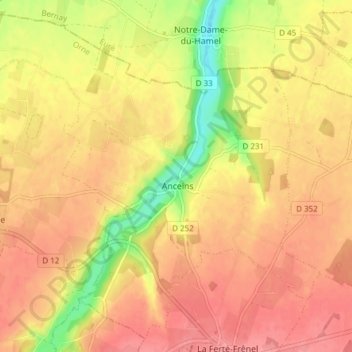
Nom : Carte topographique Anceins, altitude, relief.
Altitude moyenne : 239 m
Altitude minimum : 188 m
Altitude maximum : 266 m
Autres cartes topographiques
Cliquez sur une carte pour visualiser sa topographie, son altitude et son relief.
Glos-la-Ferrière
France > Normandie > Orne > La Ferté-en-Ouche
Glos-la-Ferrière, La Ferté-en-Ouche, Mortagne-au-Perche, Orne, Normandie, France métropolitaine, 61550, France
Altitude moyenne : 239 m
Bocquencé
France > Normandie > Orne > La Ferté-en-Ouche
Bocquencé, La Ferté-en-Ouche, Mortagne-au-Perche, Orne, Normandie, France métropolitaine, 61550, France
Altitude moyenne : 259 m
La Ferté-Frênel
France > Normandie > Orne > La Ferté-en-Ouche
La Ferté-Frênel, La Ferté-en-Ouche, Mortagne-au-Perche, Orne, Normandie, France métropolitaine, 61550, France
Altitude moyenne : 264 m