
Carte topographique Kfour
Carte interactive
Cliquez sur la carte pour afficher l’altitude.
À propos de cette carte
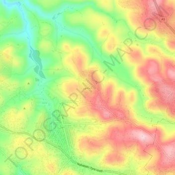
Nom : Carte topographique Kfour, altitude, relief.
Lieu : Kfour, Nabatieh District, Nabatieh Governorate, 1700, Lebanon (33.37832 35.43179 33.41832 35.47179)
Altitude moyenne : 404 m
Altitude minimum : 281 m
Altitude maximum : 518 m
Kfour (Arabic:كفور) is a village and municipality in the Keserwan District of the Keserwan-Jbeil Governorate in Lebanon. Its average elevation is 830 metres (2723 ft) above sea level and its total land area is 426 hectares. Kfour's inhabitants are almost predominantly Maronite Catholic. As of 2008, the village had a public school with 290 students and a private school with 326 students; it also has a company with over 5 employees.
Autres cartes topographiques
Cliquez sur une carte pour visualiser sa topographie, son altitude et son relief.
Qaaqaait El Jisr
Lebanon > Nabatieh Governorate
Qaaqaait El Jisr, Nabatieh District, Nabatieh Governorate, Lebanon
Altitude moyenne : 303 m
Haris
Lebanon > Nabatieh Governorate
Haris, Bint Jbeil District, Nabatieh Governorate, Lebanon
Altitude moyenne : 666 m
Tibnine
Lebanon > Nabatieh Governorate
Tibnine, Bint Jbeil District, Nabatieh Governorate, 1702, Lebanon
Altitude moyenne : 626 m
Bani Haiyane
Lebanon > Nabatieh Governorate
Bani Haiyane, Marjayoun District, Nabatieh Governorate, Lebanon
Altitude moyenne : 476 m
Khiam
Lebanon > Nabatieh Governorate
Khiam, Marjayoun District, Nabatieh Governorate, Lebanon
Altitude moyenne : 519 m
Kafr Tibnit
Lebanon > Nabatieh Governorate
Kafr Tibnit, Nabatieh District, Nabatieh Governorate, 1700, Lebanon
Altitude moyenne : 493 m
Ayta Ash Shab
Lebanon > Nabatieh Governorate
Ayta Ash Shab, Aayta Ech Chaab, Bint Jbeil District, Nabatieh Governorate, Lebanon
Altitude moyenne : 622 m
al sanawbar
Lebanon > Nabatieh Governorate > Rmaich
al sanawbar, Rmaich, Bint Jbeil District, Nabatieh Governorate, Lebanon
Altitude moyenne : 625 m
Marjayoun
Lebanon > Nabatieh Governorate
Marjayoun, Marjayoun District, Nabatieh Governorate, 1701, Lebanon
Altitude moyenne : 651 m
Tibnine
Lebanon > Nabatieh Governorate
Tibnine, Bint Jbeil District, Nabatieh Governorate, 1702, Lebanon
Altitude moyenne : 629 m
Zebdine
Lebanon > Nabatieh Governorate > Zebdine
Zebdine, Nabatieh District, Nabatieh Governorate, 1700, Lebanon
Altitude moyenne : 450 m
Insar
Lebanon > Nabatieh Governorate
Insar, Nabatieh District, Nabatieh Governorate, Lebanon
Altitude moyenne : 247 m
Kafr Rumman
Lebanon > Nabatieh Governorate > Kafr Rumman
Kafr Rumman, Nabatieh District, Nabatieh Governorate, 1700, Lebanon
Altitude moyenne : 485 m
Chaqra
Lebanon > Nabatieh Governorate
Chaqra, Bint Jbeil District, Nabatieh Governorate, Lebanon
Altitude moyenne : 636 m
Marjayoun
Lebanon > Nabatieh Governorate > Marjayoun
Marjayoun, Marjayoun District, Nabatieh Governorate, 1701, Lebanon
Altitude moyenne : 569 m
Klayaa
Lebanon > Nabatieh Governorate > Klayaa
Klayaa, Marjayoun District, Nabatieh Governorate, 1701, Lebanon
Altitude moyenne : 528 m
Rachaiya El Foukhar
Lebanon > Nabatieh Governorate
Rachaiya El Foukhar, Hasbaya District, Nabatieh Governorate, Lebanon
Altitude moyenne : 618 m
Meiss Ej-Jabal
Lebanon > Nabatieh Governorate
Meiss Ej-Jabal, Marjayoun District, Nabatieh Governorate, Lebanon
Altitude moyenne : 630 m
Bint Jubayl
Lebanon > Nabatieh Governorate
Bint Jubayl, Bent Jbayl, Bint Jbeil District, Nabatieh Governorate, Lebanon
Altitude moyenne : 732 m
Khiam
Lebanon > Nabatieh Governorate
Khiam, Khiyam, Marjayoun District, Nabatieh Governorate, 1701, Lebanon
Altitude moyenne : 577 m
Nabatieh
Lebanon > Nabatieh Governorate
Nabatieh, Nabatieh Et Tahta, Nabatieh District, Nabatieh Governorate, 1700, Lebanon
Altitude moyenne : 469 m