
Carte topographique Kokanee Creek Provincial Park
Carte interactive
Cliquez sur la carte pour afficher l’altitude.
À propos de cette carte
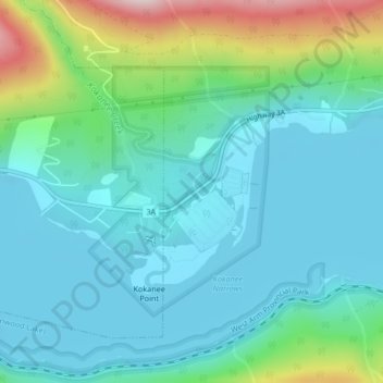
Nom : Carte topographique Kokanee Creek Provincial Park, altitude, relief.
Altitude moyenne : 617 m
Altitude minimum : 527 m
Altitude maximum : 944 m
Autres cartes topographiques
Cliquez sur une carte pour visualiser sa topographie, son altitude et son relief.
West Arm Provincial Park
Canada > British Columbia > Regional District of Central Kootenay > Area E (Balfour/Cottonwood Lake)
West Arm Provincial Park, Area E (Balfour/Cottonwood Lake), Regional District of Central Kootenay, British Columbia, Canada
Altitude moyenne : 1 449 m
Granite
Canada > British Columbia > Regional District of Central Kootenay > Area E (Balfour/Cottonwood Lake) > Blewett
Granite, Blewett, Area E (Balfour/Cottonwood Lake), Regional District of Central Kootenay, British Columbia, V1L 6X4, Canada
Altitude moyenne : 772 m
Ross-White Lady Lake Recreation Site
Canada > British Columbia > Regional District of Central Kootenay > Area E (Balfour/Cottonwood Lake)
Ross-White Lady Lake Recreation Site, Area E (Balfour/Cottonwood Lake), Regional District of Central Kootenay, British Columbia, Canada
Altitude moyenne : 1 858 m
Blewett
Canada > British Columbia > Regional District of Central Kootenay > Area E (Balfour/Cottonwood Lake) > Blewett
Blewett, Area E (Balfour/Cottonwood Lake), Regional District of Central Kootenay, British Columbia, V1L 6X4, Canada
Altitude moyenne : 837 m
Area E (Balfour/Cottonwood Lake)
Canada > British Columbia > Regional District of Central Kootenay > Area E (Balfour/Cottonwood Lake)
Area E (Balfour/Cottonwood Lake), Regional District of Central Kootenay, British Columbia, Canada
Altitude moyenne : 1 433 m
Kokanee Creek
Canada > British Columbia > Regional District of Central Kootenay > Area E (Balfour/Cottonwood Lake)
Kokanee Creek, Area E (Balfour/Cottonwood Lake), Regional District of Central Kootenay, British Columbia, Canada
Altitude moyenne : 2 022 m
Balfour
Canada > British Columbia > Regional District of Central Kootenay > Area E (Balfour/Cottonwood Lake)
Balfour, Area E (Balfour/Cottonwood Lake), Regional District of Central Kootenay, British Columbia, V0G 1C0, Canada
Altitude moyenne : 673 m