Géolocaliser

Carte topographique Christmas Island

Cliquez sur la carte pour afficher l’altitude.

Christmas Island

Steep cliffs along much of the coast rise abruptly to a central plateau. Elevation ranges from sea level to 361 m (1,184 ft) at Murray Hill. The island is mainly tropical rainforest, 63% of which is national parkland. The narrow fringing reef surrounding the island poses a maritime hazard.

Wikipedia (CC-BY-SA 3.0)

À propos de cette carte

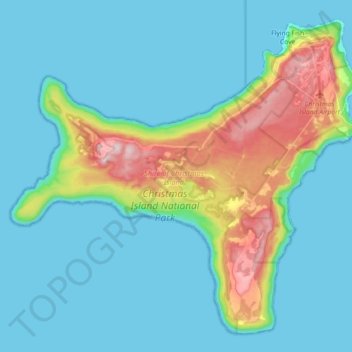
Nom : Carte topographique Christmas Island, altitude, relief.

Lieu : Christmas Island, Flying Fish Cove, Shire of Christmas Island, Christmas Island, 6798, Australia (-10.57008 105.53344 -10.41230 105.71302)

Altitude moyenne : 69 m

Altitude minimum : 0 m

Altitude maximum : 363 m

Équipez-vous pour votre prochaine aventure :

🗺️Carte du monde à gratter - Cadeau idéal pour suivre ses explorations passées
Tentes légères - Tentes compactes pour trekking
🛏️Matelas de sol - Isolation et confort pour dormir en plein air
🧭Altimètres baromètres - Mesure altitude et pression
🧊Glacières souples - Transport nourriture et boissons

En tant que Partenaire Amazon, ce site perçoit une commission sur les achats éligibles sans surcoût pour vous.