
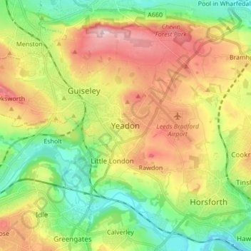
Carte topographique Yeadon
Carte interactive
Cliquez sur la carte pour afficher l’altitude.
À propos de cette carte
Nom : Carte topographique Yeadon, altitude, relief.
Altitude moyenne : 142 m
Altitude minimum : 39 m
Altitude maximum : 281 m
Autres cartes topographiques
Cliquez sur une carte pour visualiser sa topographie, son altitude et son relief.
Churwell
United Kingdom > England > Leeds
Churwell, Leeds, West Yorkshire, England, LS27 7QR, United Kingdom
Altitude moyenne : 96 m
Ledston
United Kingdom > England > Leeds
Ledston, Leeds, West Yorkshire, England, United Kingdom
Altitude moyenne : 45 m
East Rigton
United Kingdom > England > Leeds
East Rigton, Leeds, West Yorkshire, England, LS17 9AZ, United Kingdom
Altitude moyenne : 72 m
Bramhope
United Kingdom > England > Leeds > Bramhope
Bramhope, Leeds, West Yorkshire, England, United Kingdom
Altitude moyenne : 143 m
Boston Spa
United Kingdom > England > Leeds > Wetherby
Boston Spa, Wetherby, Leeds, West Yorkshire, England, United Kingdom
Altitude moyenne : 34 m
Kippax
United Kingdom > England > Leeds > Great Preston
Kippax, Great Preston, Leeds, West Yorkshire, England, United Kingdom
Altitude moyenne : 56 m
Guiseley
United Kingdom > England > Leeds
Guiseley, Leeds, West Yorkshire, England, LS20 9FN, United Kingdom
Altitude moyenne : 140 m
Limekiln
United Kingdom > England > Leeds
Limekiln, Leeds, Yorkshire and the Humber, England, LS15 4DF, United Kingdom
Altitude moyenne : 89 m