
Carte topographique l'Estartit
Carte interactive
Cliquez sur la carte pour afficher l’altitude.
À propos de cette carte
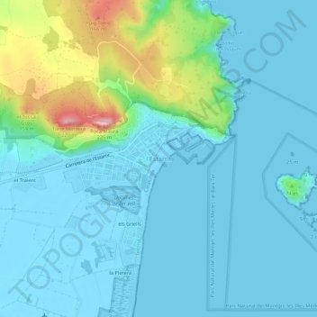
Nom : Carte topographique l'Estartit, altitude, relief.
Altitude moyenne : 34 m
Altitude minimum : -5 m
Altitude maximum : 199 m
Autres cartes topographiques
Cliquez sur une carte pour visualiser sa topographie, son altitude et son relief.
Els Griells
Spanje > Catalonië > Baix Empordà > Torroella de Montgrí > l'Estartit
Els Griells, l'Estartit, Torroella de Montgrí, Baix Empordà, Gerona, Catalonië, 17130, Spanje
Altitude moyenne : 20 m