
Carte topographique Barnstaple
Carte interactive
Cliquez sur la carte pour afficher l’altitude.
À propos de cette carte
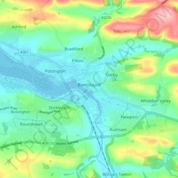
Nom : Carte topographique Barnstaple, altitude, relief.
Lieu : Barnstaple, North Devon, Devon, England, United Kingdom (51.06340 -4.08995 51.09456 -4.00251)
Altitude moyenne : 47 m
Altitude minimum : -2 m
Altitude maximum : 164 m
Autres cartes topographiques
Cliquez sur une carte pour visualiser sa topographie, son altitude et son relief.
Swimbridge
United Kingdom > England > Devon > North Devon
Swimbridge, North Devon, Devon, England, United Kingdom
Altitude moyenne : 126 m
St John's Chapel
United Kingdom > England > Devon > North Devon > Eastacombe
St John's Chapel, Tawstock, Eastacombe, North Devon, Devon, England, EX31 3PB, United Kingdom
Altitude moyenne : 78 m
Ilfracombe
United Kingdom > England > Devon > North Devon
Ilfracombe, North Devon, Devon, England, United Kingdom
Altitude moyenne : 104 m
Lynmouth
United Kingdom > England > Devon > North Devon > Lynmouth
Lynmouth, North Devon, Devon, England, EX35 6ES, United Kingdom
Altitude moyenne : 128 m
Thornland Wood
United Kingdom > England > Devon > North Devon
Thornland Wood, Berrynarbor, North Devon, Devon, South West England, England, EX31 4NX, United Kingdom
Altitude moyenne : 186 m