
Carte topographique Hidden Glacier
Carte interactive
Cliquez sur la carte pour afficher l’altitude.
À propos de cette carte
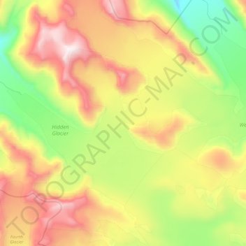
Nom : Carte topographique Hidden Glacier, altitude, relief.
Lieu : Hidden Glacier, Yakutat, Alaska, USA (59.67108 -139.20005 59.74325 -138.96316)
Altitude moyenne : 821 m
Altitude minimum : 204 m
Altitude maximum : 1 556 m
Autres cartes topographiques
Cliquez sur une carte pour visualiser sa topographie, son altitude et son relief.
North Pole
USA > Alaska > North Pole
North Pole, Fairbanks North Star, Alaska, USA
Altitude moyenne : 149 m
Mendenhaven
USA > Alaska > Mendenhaven
Mendenhaven, Juneau, Alaska, 99801, USA
Altitude moyenne : 126 m
Kuskokwim River
Kuskokwim River, Unorganized Borough, Alaska, USA
Altitude moyenne : 111 m
Shadows Glacier
Shadows Glacier, Matanuska-Susitna, Alaska, USA
Altitude moyenne : 1 464 m
Mount Cleveland
Mount Cleveland, Unorganized Borough, Alaska, USA
Altitude moyenne : 1 022 m
Tokositna Glacier
Tokositna Glacier, Matanuska-Susitna, Alaska, USA
Altitude moyenne : 1 485 m
Martin River Glacier
Martin River Glacier, Valdez-Cordova, Alaska, USA
Altitude moyenne : 844 m
Denali National Park and Preserve
Denali National Park and Preserve, Denali, Alaska, USA
Altitude moyenne : 777 m
Matanuska Glacier
Matanuska Glacier, Matanuska-Susitna, Alaska, USA
Altitude moyenne : 1 819 m
Admiralty Island
Admiralty Island, Hoonah-Angoon, Alaska, 99820, USA
Altitude moyenne : 295 m
Grewingk Glacier
Grewingk Glacier, Kenai Peninsula, Alaska, USA
Altitude moyenne : 1 008 m
Mount Marcus Baker
Mount Marcus Baker, Matanuska-Susitna, Alaska, USA
Altitude moyenne : 3 435 m
Madre de Dios Island
Madre de Dios Island, Prince of Wales-Hyder, Alaska, USA
Altitude moyenne : 12 m
Exit Glacier
Exit Glacier, Harding Ice Field Approach Trail, Kenai Peninsula, Alaska, USA
Altitude moyenne : 1 092 m
Worthington Glacier
Worthington Glacier, Richardson Highway, Ptarmigan, Valdez-Cordova, Alaska, USA
Altitude moyenne : 1 356 m
Eldridge Glacier
Eldridge Glacier, Matanuska-Susitna, Alaska, USA
Altitude moyenne : 1 074 m