
Carte topographique Chester Township
Carte interactive
Cliquez sur la carte pour afficher l’altitude.
À propos de cette carte
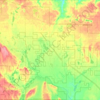
Nom : Carte topographique Chester Township, altitude, relief.
Lieu : Chester Township, Otsego County, Michigan, United States (44.85690 -84.60674 45.02757 -84.48612)
Altitude moyenne : 392 m
Altitude minimum : 345 m
Altitude maximum : 441 m
Autres cartes topographiques
Cliquez sur une carte pour visualiser sa topographie, son altitude et son relief.
Vanderbilt
United States > Michigan > Otsego County
Vanderbilt, Corwith Township, Otsego County, Michigan, 49795, United States
Altitude moyenne : 334 m
Charlton Township
United States > Michigan > Otsego County
Charlton Township, Otsego County, Michigan, 49751, United States
Altitude moyenne : 368 m
Apache Lake
United States > Michigan > Otsego County
Apache Lake, Bagley Township, Otsego County, Michigan, United States
Altitude moyenne : 392 m
Pigeon River Country State Forest
United States > Michigan > Otsego County
Pigeon River Country State Forest, Otsego County, Michigan, United States
Altitude moyenne : 289 m
Gaylord
United States > Michigan > Otsego County > Gaylord
Gaylord, Otsego County, Michigan, United States
Altitude moyenne : 401 m