
Carte topographique Qujing
Carte interactive
Cliquez sur la carte pour afficher l’altitude.
À propos de cette carte
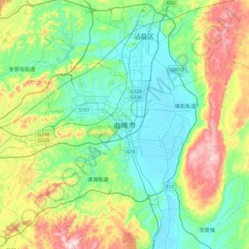
Nom : Carte topographique Qujing, altitude, relief.
Lieu : Qujing, Qilin District, Qujing City, Yunnan, China (25.33027 103.63654 25.65027 103.95654)
Altitude moyenne : 2 019 m
Altitude minimum : 1 850 m
Altitude maximum : 2 440 m
Tempered by the low latitude and moderate elevation, Qujing has a mild subtropical highland climate (Köppen Cwb), with short, mild, dry winters, and warm, rainy summers. Frost may occur in winter but the days still generally warm up to around 15 °C (59 °F). During summer, a majority of the days features some rainfall, and daytime temperatures rise to 25 °C (77 °F). A great majority of the year's rainfall occurs from June to October.