
Carte topographique Pukanec
Carte interactive
Cliquez sur la carte pour afficher l’altitude.
À propos de cette carte
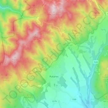
Nom : Carte topographique Pukanec, altitude, relief.
Altitude moyenne : 462 m
Altitude minimum : 259 m
Altitude maximum : 743 m
The village lies at an altitude of 354 metres and covers an area of 26.196 km2. It has a population of 2067 people. It is located near the Štiavnica Mountains, in the Sikenica river valley. It is located around 18 km northeast of Levice.
Autres cartes topographiques
Cliquez sur une carte pour visualiser sa topographie, son altitude et son relief.
Nový Tekov
Slovakia > Region of Nitra > District of Levice
Nový Tekov, District of Levice, Region of Nitra, Western Slovakia, 935 33, Slovakia
Altitude moyenne : 176 m
Veľký Ďur
Slovakia > Region of Nitra > District of Levice
Veľký Ďur, District of Levice, Region of Nitra, Western Slovakia, 935 34, Slovakia
Altitude moyenne : 192 m