
Carte topographique Binh Ba Commune
Carte interactive
Cliquez sur la carte pour afficher l’altitude.
À propos de cette carte
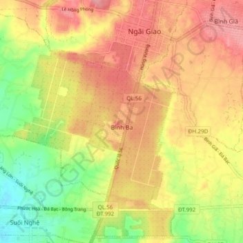
Nom : Carte topographique Binh Ba Commune, altitude, relief.
Altitude moyenne : 90 m
Altitude minimum : 35 m
Altitude maximum : 132 m
Autres cartes topographiques
Cliquez sur une carte pour visualiser sa topographie, son altitude et son relief.
Núi Nứa
Vietnam > Bà Rịa - Vũng Tàu Province > Chau Duc District > Xuan Son Commune
Núi Nứa, Xuan Son Commune, Chau Duc District, Bà Rịa - Vũng Tàu Province, Vietnam
Altitude moyenne : 78 m
Tân Thành
Vietnam > Bà Rịa - Vũng Tàu Province > Chau Duc District > Quang Thanh Commune
Tân Thành, Quang Thanh Commune, Chau Duc District, Bà Rịa - Vũng Tàu Province, Vietnam
Altitude moyenne : 135 m