
Carte topographique Entwicklungsregion West
Carte interactive
Cliquez sur la carte pour afficher l’altitude.
À propos de cette carte
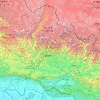
Nom : Carte topographique Entwicklungsregion West, altitude, relief.
Lieu : Entwicklungsregion West, Nepal (27.33016 82.69618 29.33061 85.19783)
Altitude moyenne : 2 421 m
Altitude minimum : 81 m
Altitude maximum : 7 949 m
Autres cartes topographiques
Cliquez sur une carte pour visualiser sa topographie, son altitude et son relief.
Karte
Nepal > Entwicklungsregion West > Karte
Karte, मनाङ (Manang), Gandaki, Entwicklungsregion West, Nepal
Altitude moyenne : 2 579 m
Andheri
Nepal > Entwicklungsregion West > Andheri
Andheri, बागलुङ (Baglung), धौलागिरी अञ्चल, Entwicklungsregion West, Nepal
Altitude moyenne : 901 m
Muna
Nepal > Entwicklungsregion West > Muna
Muna, म्याग्दी (Myagdi), धौलागिरी अञ्चल, Entwicklungsregion West, Nepal
Altitude moyenne : 2 230 m
Kali Gandaki
Nepal > Entwicklungsregion West > Chhusang
Kali Gandaki, Chhusang, मुस्ताङ (Mustang), धौलागिरी अञ्चल, Entwicklungsregion West, Nepal
Altitude moyenne : 3 247 m
Mudi
Nepal > Entwicklungsregion West > Mudi
Mudi, म्याग्दी (Myagdi), धौलागिरी अञ्चल, Entwicklungsregion West, Nepal
Altitude moyenne : 4 189 m
Pokhara
Nepal > Entwicklungsregion West > Pokhara
Pokhara, Pokhara Lekhnath Metropolitan, कास्की, Gandaki, Entwicklungsregion West, 3, Nepal
Altitude moyenne : 1 222 m
Darling
Nepal > Entwicklungsregion West > Darling
Darling, गुल्मी (Gulmi), लुम्बिनी अञ्चल, Entwicklungsregion West, Nepal
Altitude moyenne : 1 681 m
Annapurna Himal
Nepal > Entwicklungsregion West > Ghandruk
Annapurna Himal, Ghandruk, कास्की, Gandaki, Entwicklungsregion West, Nepal
Altitude moyenne : 3 675 m