
Faire un don
Équipez-vous pour votre prochaine aventure :
En tant que Partenaire Amazon, ce site perçoit une commission sur les achats éligibles sans surcoût pour vous.
Carte topographique Ambuklao Dam
Cliquez sur la carte pour afficher l’altitude.
Faire un don
Équipez-vous pour votre prochaine aventure :
En tant que Partenaire Amazon, ce site perçoit une commission sur les achats éligibles sans surcoût pour vous.
Ambuklao Dam
SNAP-Benguet began a massive rehabilitation project that restored Ambuklao to operating status and increased its capacity from 75 MW to 105 MW. The project required the construction of a new intake, headrace and penstock, elevation of tailrace tunnel outlet, de-silting of tailrace tunnel and replacement of electro-mechanical components. In June 2011, Unit 3 became the first turbine unit to go on-line, followed by the other two units. Ambuklao was formally inaugurated in October 2011.
Faire un don
Équipez-vous pour votre prochaine aventure :
En tant que Partenaire Amazon, ce site perçoit une commission sur les achats éligibles sans surcoût pour vous.
À propos de cette carte
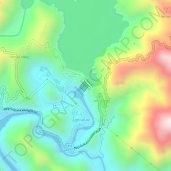
Nom : Carte topographique Ambuklao Dam, altitude, relief.
Altitude moyenne : 808 m
Altitude minimum : 598 m
Altitude maximum : 1 190 m
Faire un don
Équipez-vous pour votre prochaine aventure :
En tant que Partenaire Amazon, ce site perçoit une commission sur les achats éligibles sans surcoût pour vous.