
Carte topographique Lipa
Carte interactive
Cliquez sur la carte pour afficher l’altitude.
À propos de cette carte
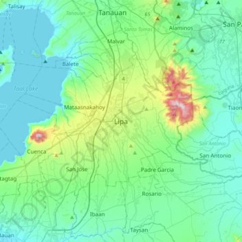
Nom : Carte topographique Lipa, altitude, relief.
Lieu : Lipa, Batangas, Calabarzon, 4217, Philippines (13.78147 121.00429 14.10147 121.32429)
Altitude moyenne : 163 m
Altitude minimum : -4 m
Altitude maximum : 955 m
At the celebration of the elevation of Lipa to a city in January 1888, José Rizal was invited by Dr. Jose Lozada, Catalino Dimayuga and the brothers Celestino and Simeon Luz but Rizal responded only with his Hymno Al Trabajo which he dedicated to the zeal and industry of the Lipeños.