
Carte topographique Ballynabortagh
Carte interactive
Cliquez sur la carte pour afficher l’altitude.
À propos de cette carte
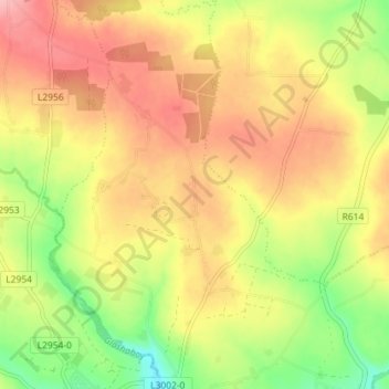
Nom : Carte topographique Ballynabortagh, altitude, relief.
Altitude moyenne : 153 m
Altitude minimum : 86 m
Altitude maximum : 208 m
Autres cartes topographiques
Cliquez sur une carte pour visualiser sa topographie, son altitude et son relief.
Coosane
Ireland > County Cork > Municipal District of Cobh
Coosane, Watergrasshill, Municipal District of Cobh, County Cork, Munster, Ireland
Altitude moyenne : 108 m
Lysaghtstown
Ireland > County Cork > Municipal District of Cobh
Lysaghtstown, Carrigtohill ED, Municipal District of Cobh, County Cork, Munster, Ireland
Altitude moyenne : 81 m
Tullagreen
Ireland > County Cork > Municipal District of Cobh
Tullagreen, Carrigtohill ED, Municipal District of Cobh, County Cork, Munster, Ireland
Altitude moyenne : 12 m
Ballynanelagh
Ireland > County Cork > Municipal District of Cobh > Knockraha
Ballynanelagh, Knockraha, Municipal District of Cobh, County Cork, Munster, Ireland
Altitude moyenne : 113 m