
Carte topographique Municipio 2
Carte interactive
Cliquez sur la carte pour afficher l’altitude.
À propos de cette carte
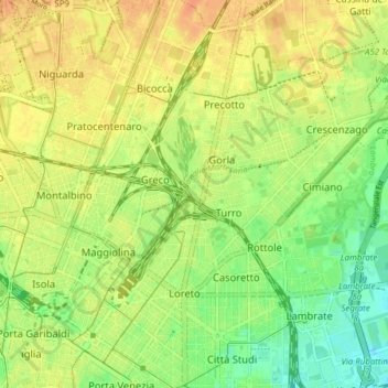
Nom : Carte topographique Municipio 2, altitude, relief.
Lieu : Municipio 2, Milan, Lombardy, Italy (45.47654 9.19142 45.52372 9.26868)
Altitude moyenne : 132 m
Altitude minimum : 113 m
Altitude maximum : 146 m
Autres cartes topographiques
Cliquez sur une carte pour visualiser sa topographie, son altitude et son relief.
Ronchetto delle Rane
Italy > Lombardy > Milan > Ronchetto delle Rane
Ronchetto delle Rane, Milan, Lombardy, 20142, Italy
Altitude moyenne : 105 m