
Carte topographique Cedar City
Carte interactive
Cliquez sur la carte pour afficher l’altitude.
Cedar City
Cedar City is located in the southeast Great Basin and is approximately 20 miles (32 km) north of the northeastern edge of the Mojave Desert. Its elevation of 5,846 feet (1,782 m) gives it a somewhat cooler climate compared to the nearby St. George region, though it retains cultural ties to the city —for example, they share a daily newspaper.
À propos de cette carte
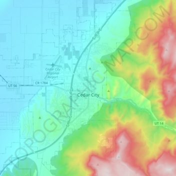
Nom : Carte topographique Cedar City, altitude, relief.
Lieu : Cedar City, Iron County, Utah, United States (37.61847 -113.19797 37.74748 -113.01272)
Altitude moyenne : 1 975 m
Altitude minimum : 1 676 m
Altitude maximum : 2 866 m
Autres cartes topographiques
Cliquez sur une carte pour visualiser sa topographie, son altitude et son relief.