
Carte topographique Orange County
Carte interactive
Cliquez sur la carte pour afficher l’altitude.
À propos de cette carte
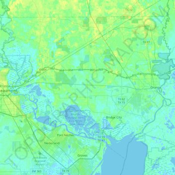
Nom : Carte topographique Orange County, altitude, relief.
Lieu : Orange County, Texas, United States of America (29.93956 -94.11889 30.24266 -93.68843)
Altitude moyenne : 4 m
Altitude minimum : -6 m
Altitude maximum : 17 m
The geography of Orange County varies relatively little, with an elevation that reaches 33 ft (10 m) above sea level at very few points within the county. Orange County is very flat, and its soil is quite sandy, as could be expected in a county along the Gulf of Mexico. (Sandy soil is also common in southern Louisiana, Mississippi, and Alabama, and in western and southern Florida.) Saltwater marshes occur in much of the southeastern part of Orange County that borders the Sabine River. The Piney Woods are in the northern part of the county.
Autres cartes topographiques
Cliquez sur une carte pour visualiser sa topographie, son altitude et son relief.
Bryan
United States of America > Texas > Bryan
Bryan, Brazos County, Texas, United States of America
Altitude moyenne : 94 m
Coppell
United States of America > Texas > Coppell
Coppell, Dallas County, Texas, 75019, United States of America
Altitude moyenne : 160 m
Duval County
United States of America > Texas
Duval County, Texas, United States of America
Altitude moyenne : 144 m
Jefferson County
United States of America > Texas
Jefferson County, Texas, United States of America
Altitude moyenne : 5 m
Madison County
United States of America > Texas
Madison County, Texas, United States of America
Altitude moyenne : 91 m
Bexar County
United States of America > Texas
Bexar County, Texas, United States of America
Altitude moyenne : 250 m