
Carte topographique Dodoma
Carte interactive
Cliquez sur la carte pour afficher l’altitude.
À propos de cette carte
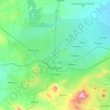
Nom : Carte topographique Dodoma, altitude, relief.
Altitude moyenne : 1 144 m
Altitude minimum : 1 049 m
Altitude maximum : 1 468 m
The official capital since 1996, Dodoma was envisaged as the first non-monumental capital city as opposed to the monumentality and hierarchy of other planned capital cities such as Abuja, Yamoussoukro, Brasília and Washington, D.C. It rejected geometrical forms such as grid iron and radial plans as inappropriate as the urban form was intended to undulate and curve with the existing topography and not in conflict with it so as to retain its rural ujamaa feel. As befitted Tanzania's development at the time, the car was seen as secondary in importance to public transports such as buses which were then utilised by much of the population.