
Carte topographique Gebbies Valley
Carte interactive
Cliquez sur la carte pour afficher l’altitude.
À propos de cette carte
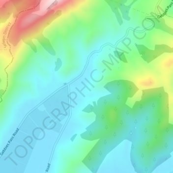
Nom : Carte topographique Gebbies Valley, altitude, relief.
Altitude moyenne : 100 m
Altitude minimum : 3 m
Altitude maximum : 393 m
Autres cartes topographiques
Cliquez sur une carte pour visualiser sa topographie, son altitude et son relief.
Christchurch
New Zealand > Canterbury > Christchurch
Christchurch, Linwood-Central-Heathcote Community, Christchurch City, Canterbury, 8011, New Zealand
Altitude moyenne : 54 m
Twyford Reserve
New Zealand > Canterbury > Christchurch
Twyford Reserve, Bishopdale, Christchurch, Christchurch City, Canterbury, New Zealand
Altitude moyenne : 21 m
Scarborough Beach
New Zealand > Canterbury > Christchurch
Scarborough Beach, Sumner, Christchurch, Christchurch City, Canterbury, New Zealand
Altitude moyenne : 44 m