
Carte topographique Brunssummerheide
Carte interactive
Cliquez sur la carte pour afficher l’altitude.
À propos de cette carte
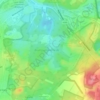
Nom : Carte topographique Brunssummerheide, altitude, relief.
Altitude moyenne : 104 m
Altitude minimum : 70 m
Altitude maximum : 164 m
Autres cartes topographiques
Cliquez sur une carte pour visualiser sa topographie, son altitude et son relief.
Wilhelminaberg
Nederland > Limburg > Landgraaf
Wilhelminaberg, Landgraaf, Limburg, Nederland, 6372VG, Nederland
Altitude moyenne : 147 m
Kasteel Strijthagen
Nederland > Limburg > Landgraaf
Kasteel Strijthagen, Rouenhof, Eikske, Landgraaf, Limburg, Nederland, 6372PW, Nederland
Altitude moyenne : 137 m