
Faire un don
Équipez-vous pour votre prochaine aventure :
En tant que Partenaire Amazon, ce site perçoit une commission sur les achats éligibles sans surcoût pour vous.
Carte topographique Spießhorn
Cliquez sur la carte pour afficher l’altitude.
Faire un don
Équipez-vous pour votre prochaine aventure :
En tant que Partenaire Amazon, ce site perçoit une commission sur les achats éligibles sans surcoût pour vous.
À propos de cette carte
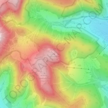
Nom : Carte topographique Spießhorn, altitude, relief.
Altitude moyenne : 1 123 m
Altitude minimum : 883 m
Altitude maximum : 1 364 m
Faire un don
Équipez-vous pour votre prochaine aventure :
En tant que Partenaire Amazon, ce site perçoit une commission sur les achats éligibles sans surcoût pour vous.
Autres cartes topographiques
Cliquez sur une carte pour visualiser sa topographie, son altitude et son relief.
Albbruck
Germany > Baden-Württemberg > Landkreis Waldshut
The municipality is crossed by the chine valleys of the Mühlbach and Alb rivers. The valley [de] of the former is a Federally-protected nature reserve and the latter forms part of the municipality's northwest border. Elevation above sea level in the municipal area ranges from a high of 729 meters (2,392 ft)…
Altitude moyenne : 534 m
Menzenschwand
Germany > Baden-Württemberg > Landkreis Waldshut > St. Blasien
Altitude moyenne : 1 083 m
Faire un don
Équipez-vous pour votre prochaine aventure :
En tant que Partenaire Amazon, ce site perçoit une commission sur les achats éligibles sans surcoût pour vous.
Faire un don
Équipez-vous pour votre prochaine aventure :
En tant que Partenaire Amazon, ce site perçoit une commission sur les achats éligibles sans surcoût pour vous.
Faire un don
Équipez-vous pour votre prochaine aventure :
En tant que Partenaire Amazon, ce site perçoit une commission sur les achats éligibles sans surcoût pour vous.