
Carte topographique Behbahan
Carte interactive
Cliquez sur la carte pour afficher l’altitude.
À propos de cette carte
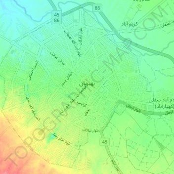
Nom : Carte topographique Behbahan, altitude, relief.
Lieu : Behbahan, بخش مرکزی, Behbahan County, Khuzestan Province, Iran (30.56730 50.20974 30.61820 50.26803)
Altitude moyenne : 327 m
Altitude minimum : 304 m
Altitude maximum : 366 m
Autres cartes topographiques
Cliquez sur une carte pour visualiser sa topographie, son altitude et son relief.
گرمز سفلی
Iran > Khuzestan Province > Behbahan County > دهستان حومه
گرمز سفلی, دهستان حومه, بخش مرکزی, Behbahan County, Khuzestan Province, Iran
Altitude moyenne : 381 m
Behbahan
Iran > Khuzestan Province > Behbahan County > Behbahan
Behbahan, دهستان بهبهان, بخش مرکزی, Behbahan County, Khuzestan Province, 63618, Iran
Altitude moyenne : 330 m