Géolocaliser

Carte topographique Toxibó

Cliquez sur la carte pour afficher l’altitude.

À propos de cette carte

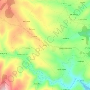
Nom : Carte topographique Toxibó, altitude, relief.

Lieu : Toxibó, Gonzar, Portomarín, Lugo, Galicia, 27188, España (42.79284 -7.68470 42.83284 -7.64470)

Altitude moyenne : 476 m

Altitude minimum : 332 m

Altitude maximum : 640 m

Autres cartes topographiques

Cliquez sur une carte pour visualiser sa topographie, son altitude et son relief.

Vilaxuste

España > Galicia > Lugo > Portomarín

Altitude moyenne : 511 m

Soengas

España > Galicia > Lugo > Portomarín

Altitude moyenne : 615 m

Castromaior

España > Galicia > Lugo > Portomarín

Altitude moyenne : 596 m

Gonzar

España > Galicia > Lugo > Portomarín

Altitude moyenne : 551 m

Castromaior

España > Galicia > Lugo > Portomarín

Altitude moyenne : 596 m

Équipez-vous pour votre prochaine aventure :

🔦Lampes frontales - Éclairage mains libres pour randonnée et camping
🩳Pantalons de randonnée - Pantalons résistants et confortables
🪜Bâtons de randonnée - Stabilité et confort en montée
📍GPS de randonnée - GPS portables pour suivre itinéraires et altitudes
🛏️Sacs de couchage - Sacs de couchage pour différentes températures

En tant que Partenaire Amazon, ce site perçoit une commission sur les achats éligibles sans surcoût pour vous.