
Faire un don
Équipez-vous pour votre prochaine aventure :
En tant que Partenaire Amazon, ce site perçoit une commission sur les achats éligibles sans surcoût pour vous.
Carte topographique Inman Valley
Cliquez sur la carte pour afficher l’altitude.
Faire un don
Équipez-vous pour votre prochaine aventure :
En tant que Partenaire Amazon, ce site perçoit une commission sur les achats éligibles sans surcoût pour vous.
Inman Valley
In the valley is Selwyn Rock (35°29′47″S 138°30′45″E / 35.4965°S 138.5124°E / -35.4965; 138.5124) a glaciated pavement in the bed of the Inman River. It was first described in 1859 by, and later named for, A.R.C. Selwyn, who was Victorian Government geologist at the time. Glacial grooves and striations on the polished surface indicate glacial movement to the north-west. Boulder clays, tillites and erratics are also common in the area, which underwent glaciation during the Permian (approximately 270 Ma). The pavement of Cambrian bedrock and Permian glacial sediments were exposed during the Tertiary when the Inman River eroded the topography to its present-day surface. A cafe overlooks the glaciated bed of the river, with access onto the rock available via stairs and viewing platforms.
Faire un don
Équipez-vous pour votre prochaine aventure :
En tant que Partenaire Amazon, ce site perçoit une commission sur les achats éligibles sans surcoût pour vous.
À propos de cette carte
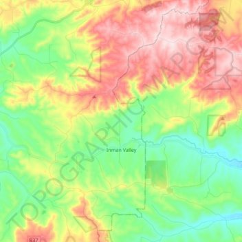
Nom : Carte topographique Inman Valley, altitude, relief.
Altitude moyenne : 212 m
Altitude minimum : 49 m
Altitude maximum : 443 m
Faire un don
Équipez-vous pour votre prochaine aventure :
En tant que Partenaire Amazon, ce site perçoit une commission sur les achats éligibles sans surcoût pour vous.
Autres cartes topographiques
Cliquez sur une carte pour visualiser sa topographie, son altitude et son relief.
Myponga River
Australia > South Australia > The District Council of Yankalilla > Myponga > Myponga Beach
Altitude moyenne : 138 m
Kalumunda Forest Reserve
Australia > South Australia > The District Council of Yankalilla
Altitude moyenne : 265 m
Mount Hayfield
Australia > South Australia > The District Council of Yankalilla
Altitude moyenne : 278 m