
Carte topographique Arborfield
Carte interactive
Cliquez sur la carte pour afficher l’altitude.
À propos de cette carte
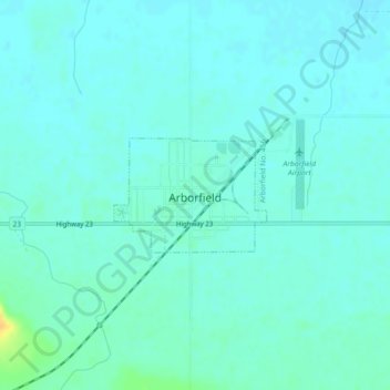
Nom : Carte topographique Arborfield, altitude, relief.
Lieu : Arborfield, Division No. 14, Saskatchewan, S0E 0A0, Canada (53.10174 -103.66949 53.10966 -103.65186)
Altitude moyenne : 362 m
Altitude minimum : 356 m
Altitude maximum : 385 m
Autres cartes topographiques
Cliquez sur une carte pour visualiser sa topographie, son altitude et son relief.
Brooksby
Canada > Saskatchewan > Division No. 14 > Willow Creek No. 458
Brooksby, Willow Creek No. 458, Division No. 14, Saskatchewan, Canada
Altitude moyenne : 436 m