
Faire un don
Équipez-vous pour votre prochaine aventure :
En tant que Partenaire Amazon, ce site perçoit une commission sur les achats éligibles sans surcoût pour vous.
Carte topographique Highland Springs
Cliquez sur la carte pour afficher l’altitude.
Faire un don
Équipez-vous pour votre prochaine aventure :
En tant que Partenaire Amazon, ce site perçoit une commission sur les achats éligibles sans surcoût pour vous.
Highland Springs
The Highland Springs are 5 miles (8.0 km) southwest of Kelseyville. They are in the edge of the mountains that border the flat Big Valley area to the west of Clear Lake (California). It is at an elevation of 1483 feet (452 m). OpenStreetMap shows the Old Toll Road branching off to the southeast from the Lakeport–Hopland Road (CA175) just east of Hopland. The road turns east, and when it passes from Mendocino County to Lake County it changes name to Highland Springs Road. It continues east through Highland Springs, then turns north past Highland Springs Reservoir to join CA29 / CA175 just east of Lampson Field and south of Lakeport.
Faire un don
Équipez-vous pour votre prochaine aventure :
En tant que Partenaire Amazon, ce site perçoit une commission sur les achats éligibles sans surcoût pour vous.
À propos de cette carte
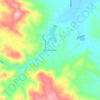
Nom : Carte topographique Highland Springs, altitude, relief.
Lieu : Highland Springs, Lake County, California, United States (38.91712 -122.92694 38.95712 -122.88694)
Altitude moyenne : 514 m
Altitude minimum : 428 m
Altitude maximum : 664 m
Faire un don
Équipez-vous pour votre prochaine aventure :
En tant que Partenaire Amazon, ce site perçoit une commission sur les achats éligibles sans surcoût pour vous.