
Faire un don
Équipez-vous pour votre prochaine aventure :
En tant que Partenaire Amazon, ce site perçoit une commission sur les achats éligibles sans surcoût pour vous.
Carte topographique Christian Island
Cliquez sur la carte pour afficher l’altitude.
Faire un don
Équipez-vous pour votre prochaine aventure :
En tant que Partenaire Amazon, ce site perçoit une commission sur les achats éligibles sans surcoût pour vous.
Christian Island
Christian Island is a large island in Georgian Bay close to the communities of Penetanguishene and Midland, Ontario. The island, with its neighbours Hope Island and Beckwith Island, is a 5,428.1 hectares (13,413.1 acres) Ojibwa reserve, known as Christian Island Indian Reserve No. 30. Together with the 7.5 hectares (18.5 acres) Christian Island Indian Reserve No. 30A located at Cedar Point, Ontario and the 3.1 hectares (7.7 acres) Chippewa Island Indian Reserve located in Twelve Mile Sound, 27.5 kilometres (17.1 mi) north of Christian Island, it forms the land base for the Beausoleil First Nation. Christian Islands' highest elevation is 209 metres (686 feet) above sea level.
Faire un don
Équipez-vous pour votre prochaine aventure :
En tant que Partenaire Amazon, ce site perçoit une commission sur les achats éligibles sans surcoût pour vous.
À propos de cette carte
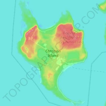
Nom : Carte topographique Christian Island, altitude, relief.
Altitude moyenne : 185 m
Altitude minimum : 171 m
Altitude maximum : 259 m
Faire un don
Équipez-vous pour votre prochaine aventure :
En tant que Partenaire Amazon, ce site perçoit une commission sur les achats éligibles sans surcoût pour vous.
Autres cartes topographiques
Cliquez sur une carte pour visualiser sa topographie, son altitude et son relief.
Wasaga Beach
Canada > Ontario > Simcoe County
The Town of Wasaga Beach covers an area of 61.13 square kilometres (23.60 sq mi) composed predominantly of sand and loamy sand that exhibit excessive to good drainage and irregular to moderately sloping topography. The poor soil quality makes it difficult to sustain lush lawns in the town. The Canada Land…
Altitude moyenne : 190 m
Faire un don
Équipez-vous pour votre prochaine aventure :
En tant que Partenaire Amazon, ce site perçoit une commission sur les achats éligibles sans surcoût pour vous.
Wasaga Beach Provincial Park
Canada > Ontario > Simcoe County > Wasaga Beach
The Town of Wasaga Beach covers an area of 61.13 square kilometres (23.60 sq mi) comprised predominantly of sand and loamy sand that exhibit excessive to good drainage and irregular to moderately sloping topography. The poor soil quality makes it difficult to sustain lush lawns in the town. The Canada Land…
Altitude moyenne : 185 m
Faire un don
Équipez-vous pour votre prochaine aventure :
En tant que Partenaire Amazon, ce site perçoit une commission sur les achats éligibles sans surcoût pour vous.
Faire un don
Équipez-vous pour votre prochaine aventure :
En tant que Partenaire Amazon, ce site perçoit une commission sur les achats éligibles sans surcoût pour vous.