
Carte topographique Nemenikuce
Carte interactive
Cliquez sur la carte pour afficher l’altitude.
À propos de cette carte
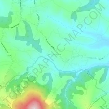
Nom : Carte topographique Nemenikuce, altitude, relief.
Altitude moyenne : 249 m
Altitude minimum : 157 m
Altitude maximum : 537 m
Autres cartes topographiques
Cliquez sur une carte pour visualiser sa topographie, son altitude et son relief.
Stojnik
Serbia > Central Serbia > City of Belgrade > Sopot Urban Municipality
Stojnik, Sopot Urban Municipality, City of Belgrade, Central Serbia, Serbia
Altitude moyenne : 230 m
Rogaca
Serbia > Central Serbia > City of Belgrade > Sopot Urban Municipality
Rogaca, Sopot Urban Municipality, City of Belgrade, Central Serbia, Serbia
Altitude moyenne : 241 m
Ropocevo
Serbia > Central Serbia > City of Belgrade > Sopot Urban Municipality
Ropocevo, Sopot Urban Municipality, City of Belgrade, Central Serbia, Serbia
Altitude moyenne : 238 m