
Carte topographique Purple Mountain
Carte interactive
Cliquez sur la carte pour afficher l’altitude.
Purple Mountain
A small mountain with an area of about 20 square kilometres (7.7 sq mi), the altitude of Purple Mountain at the top and foot of the mountain is about 448 metres (1,470 ft) and 20 metres (66 ft) respectively. The annual average rainfall is 1,000 millimetres (39 in) to 1,050 millimetres (41 in), and the average annual sunshine time is about 2,213 hours. Purple Mountain is a mountain related to many historical events of both ancient and modern China. It was originally known as Bell Mountain (traditional Chinese: 鐘山; simplified Chinese: 钟山; pinyin: Zhōngshān) and also became known as Mount Jiang (traditional Chinese: 蔣山; simplified Chinese: 蒋山; pinyin: Jiǎngshān) after Sun Quan named Jiang Ziwen, an Eastern Han official whose spirit was said to haunt the site, as the mountain's god during the Three Kingdoms era. The name Zijin (紫金) means "copper" - when copper is pure, it appears purple in color, so in Chinese, it is also called purple-gold. It is also named Mount Jinling (金陵山), due to its purple rocks. Jinling means "the mount of purple-gold". It is the origin of the nickname "Jinling" (金陵) of Nanjing. During the Ming dynasty, it was also called Mount Shenlie (神烈山).
À propos de cette carte
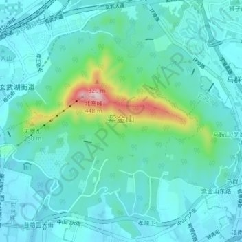
Nom : Carte topographique Purple Mountain, altitude, relief.
Altitude moyenne : 73 m
Altitude minimum : 9 m
Altitude maximum : 433 m