
Carte topographique Ahern Glacier
Carte interactive
Cliquez sur la carte pour afficher l’altitude.
À propos de cette carte
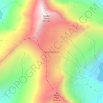
Nom : Carte topographique Ahern Glacier, altitude, relief.
Altitude moyenne : 2 214 m
Altitude minimum : 1 557 m
Altitude maximum : 2 909 m
Autres cartes topographiques
Cliquez sur une carte pour visualiser sa topographie, son altitude et son relief.
Elkhorn Hot Springs
USA > Montana > Elkhorn Hot Springs
Elkhorn Hot Springs, Beaverhead County, Montana, 59646, USA
Altitude moyenne : 2 262 m
Glacier National Park
Glacier National Park, Sperry Lake, Flathead County, Montana, USA
Altitude moyenne : 1 594 m
Pumpelly Glacier
Pumpelly Glacier, Jackson Glacier, Glacier County, Montana, USA
Altitude moyenne : 2 326 m
Two Ocean Glacier
Two Ocean Glacier, Logging Lake, Flathead County, Montana, USA
Altitude moyenne : 2 331 m
Harris Glacier
USA > Montana > Wurtz Hill
Harris Glacier, Boulder Pass, Wurtz Hill, Flathead County, Montana, USA
Altitude moyenne : 2 138 m
Gem Glacier
Gem Glacier, Highline Trail, Flathead County, Montana, USA
Altitude moyenne : 2 150 m
Dixon Glacier
USA > Montana > Wurtz Hill
Dixon Glacier, Boulder Pass, Wurtz Hill, Flathead County, Montana, USA
Altitude moyenne : 2 192 m
Wolf Glacier
Wolf Glacier, Goose Lake Jeep Trail, Park County, Montana, USA
Altitude moyenne : 3 144 m
Harrison Glacier
Harrison Glacier, Gunsight Pass, Flathead County, Montana, USA
Altitude moyenne : 2 364 m
Lupfer Glacier
Lupfer Glacier, Coal Creek, Flathead County, Montana, USA
Altitude moyenne : 2 047 m
Boulder Glacier
USA > Montana > Wurtz Hill
Boulder Glacier, Boulder Pass, Wurtz Hill, Flathead County, Montana, USA
Altitude moyenne : 2 105 m
Blacktail Mountains
Blacktail Mountains, Beaverhead County, Montana, USA
Altitude moyenne : 2 697 m
Salamander Glacier
Salamander Glacier, Garden Wall Trail, Flathead County, Montana, USA
Altitude moyenne : 2 102 m
Red Eagle Glacier
Red Eagle Glacier, Nyack Creek, Nyack, Flathead County, Montana, USA
Altitude moyenne : 2 100 m
Weasel Collar Glacier
Weasel Collar Glacier, Bowman Lake, Flathead County, Montana, USA
Altitude moyenne : 2 290 m
Running Crane Lake
Running Crane Lake, Pitamakan Pass, Glacier County, Montana, USA
Altitude moyenne : 2 333 m
Thunderbird Glacier
USA > Montana > Wurtz Hill
Thunderbird Glacier, Boulder Pass, Wurtz Hill, Flathead County, Montana, USA
Altitude moyenne : 2 162 m
Chaney Glacier
Chaney Glacier, Highline Trail, Flathead County, Montana, USA
Altitude moyenne : 2 169 m
Pryor Mountains Historical Marker
USA > Montana > Berts Trailer Court
Pryor Mountains Historical Marker, Berts Trailer Court, Carbon County, Montana, USA
Altitude moyenne : 1 097 m
Ipasha Glacier
Ipasha Glacier, Highline Trail, Flathead County, Montana, USA
Altitude moyenne : 2 122 m
Vulture Glacier
Vulture Glacier, Logging Lake, Flathead County, Montana, USA
Altitude moyenne : 2 381 m
Herbst Glacier
USA > Montana > Wurtz Hill
Herbst Glacier, Boulder Pass, Wurtz Hill, Flathead County, Montana, USA
Altitude moyenne : 2 019 m
Jackson Peak
Jackson Peak, Lewis and Clark County, Montana, USA
Altitude moyenne : 1 271 m
Kintla Glacier
USA > Montana > Wurtz Hill
Kintla Glacier, Boulder Pass, Wurtz Hill, Flathead County, Montana, USA
Altitude moyenne : 2 336 m
Sperry Glacier
Sperry Glacier, Sperry Lake, Flathead County, Montana, USA
Altitude moyenne : 2 382 m
Crazy Mountains Historical Marker
Crazy Mountains Historical Marker, Wheatland County, Montana, USA
Altitude moyenne : 1 315 m
Carter Glaciers
Carter Glaciers, Flathead County, Montana, USA
Altitude moyenne : 2 099 m
Snowbank Glacier
Snowbank Glacier, Carbon County, Montana, USA
Altitude moyenne : 3 376 m
Whitecrow Glacier
Whitecrow Glacier, Stoney Indian Pass, Glacier County, Montana, USA
Altitude moyenne : 2 339 m
Piegan Glacier
Piegan Glacier, Piegan Pass Trail, Glacier County, Montana, USA
Altitude moyenne : 2 222 m