
Carte topographique Kipkarren
Carte interactive
Cliquez sur la carte pour afficher l’altitude.
À propos de cette carte
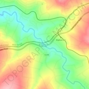
Nom : Carte topographique Kipkarren, altitude, relief.
Lieu : Kipkarren, Uasin Gishu County, Kenya (0.58775 34.94453 0.62775 34.98453)
Altitude moyenne : 1 699 m
Altitude minimum : 1 628 m
Altitude maximum : 1 773 m
Autres cartes topographiques
Cliquez sur une carte pour visualiser sa topographie, son altitude et son relief.
Kiplombe ward
Kenya > Uasin Gishu County > Turbo
Kiplombe ward, Turbo, Uasin Gishu County, Rift Valley, Kenya
Altitude moyenne : 2 033 m
Turbo
Turbo, Uasin Gishu County, Rift Valley, Kenya
Altitude moyenne : 1 908 m
Racecourse ward
Kenya > Uasin Gishu County > Kesses
Racecourse ward, Kesses, Uasin Gishu County, Rift Valley, Kenya
Altitude moyenne : 2 129 m
Strawberg
Kenya > Uasin Gishu County > Ainabkoi > Kaptagat ward
Strawberg, Kaptagat ward, Ainabkoi, Uasin Gishu County, Rift Valley, Kenya
Altitude moyenne : 2 304 m
Eldoret
Kenya > Uasin Gishu County > Moiben
Eldoret, Kimumu ward, Moiben, Uasin Gishu County, Rift Valley, 30100, Kenya
Altitude moyenne : 2 093 m
Kipkabus
Kenya > Uasin Gishu County > Kipkabus
Kipkabus, Uasin Gishu County, Kenya
Altitude moyenne : 2 495 m