
Carte topographique Forbesganj
Carte interactive
Cliquez sur la carte pour afficher l’altitude.
Forbesganj
Forbesganj is located at 26°18′N 87°15′E / 26.3°N 87.25°E / 26.3; 87.25.[4] It has an average elevation of 46 meters (150 feet). The Nepalese border is only 12 km away.
À propos de cette carte
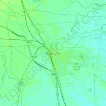
Nom : Carte topographique Forbesganj, altitude, relief.
Lieu : Forbesganj, Araria, Bihar, 854318, India (26.26491 87.22328 26.34491 87.30328)
Altitude moyenne : 61 m
Altitude minimum : 56 m
Altitude maximum : 65 m