Géolocaliser

Carte topographique Somogyacsa

Carte interactive

Cliquez sur la carte pour afficher l’altitude.

À propos de cette carte

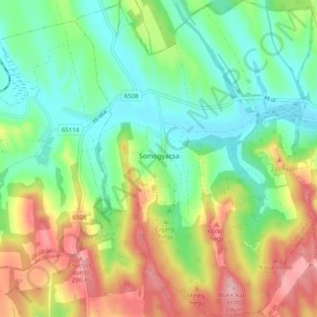
Nom : Carte topographique Somogyacsa, altitude, relief.

Lieu : Somogyacsa, Tabi járás, Somogy, Southern Transdanubia, Transdanubia, 7283, Hungary (46.56130 17.93065 46.62158 17.99770)

Altitude moyenne : 196 m

Altitude minimum : 130 m

Altitude maximum : 304 m

Autres cartes topographiques

Cliquez sur une carte pour visualiser sa topographie, son altitude et son relief.

Barcs

Hungary > Somogy

Barcs, Barcsi járás, Somogy, Southern Transdanubia, Transdanubia, Hungary

Altitude moyenne : 118 m

Karád

Hungary > Somogy

Karád, Fonyódi járás, Somogy, Southern Transdanubia, Transdanubia, 8676, Hungary

Altitude moyenne : 198 m

Kaposvár

Hungary > Somogy > Kaposvár

Kaposvár, Kaposvári járás, Somogy, Southern Transdanubia, Transdanubia, 7400, Hungary

Altitude moyenne : 173 m

Siófok

Hungary > Somogy > Siófok > Siófok

Siófok, Siófoki járás, Somogy, Southern Transdanubia, Transdanubia, 8600, Hungary

Altitude moyenne : 110 m

Nemesvid

Hungary > Somogy > Nemesvid

Nemesvid, Marcali járás, Somogy, Southern Transdanubia, Transdanubia, 8738, Hungary

Altitude moyenne : 125 m

Iharosberény

Hungary > Somogy > Iharosberény

Iharosberény, Csurgói járás, Somogy, Southern Transdanubia, Transdanubia, 8725, Hungary

Altitude moyenne : 178 m

Kaposvár

Hungary > Somogy

Kaposvár, Kaposvári járás, Somogy, Southern Transdanubia, Transdanubia, Hungary

Altitude moyenne : 162 m

Andocs

Hungary > Somogy > Andocs

Andocs, Tabi járás, Somogy, Southern Transdanubia, Transdanubia, 8675, Hungary

Altitude moyenne : 189 m

Som

Hungary > Somogy > Som

Som, Siófoki járás, Somogy, Southern Transdanubia, Transdanubia, 8655, Hungary

Altitude moyenne : 175 m