
Carte topographique Nauders - San Benedetto
Carte interactive
Cliquez sur la carte pour afficher l’altitude.
À propos de cette carte
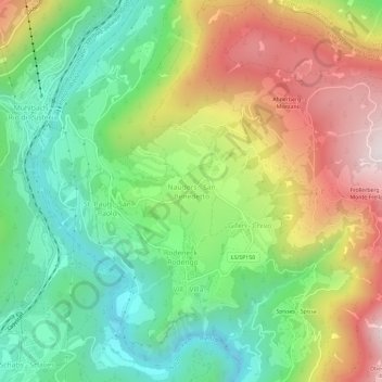
Nom : Carte topographique Nauders - San Benedetto, altitude, relief.
Altitude moyenne : 996 m
Altitude minimum : 616 m
Altitude maximum : 1 555 m
Autres cartes topographiques
Cliquez sur une carte pour visualiser sa topographie, son altitude et son relief.
Gherdëina - Grödnertal - Val Gardena
Italie > Trentin-Haut-Adige > Haut-Adige > Urtijëi - St. Ulrich in Gröden - Ortisei
Gherdëina - Grödnertal - Val Gardena, Urtijëi - St. Ulrich in Gröden - Ortisei, Salten-Schlern - Salto-Sciliar, Haut-Adige, Trentin-Haut-Adige, 39046, Italie
Altitude moyenne : 1 588 m
Bolzano - Bozen
Italie > Trentin-Haut-Adige > Haut-Adige
Bolzano - Bozen, Haut-Adige, Trentin-Haut-Adige, 39100, Italie
Altitude moyenne : 716 m
St. Martin im Kofel - San Martino al Monte
Italie > Trentin-Haut-Adige > Haut-Adige > Latsch - Laces
St. Martin im Kofel - San Martino al Monte, Latsch - Laces, Vinschgau - Val Venosta, Haut-Adige, Trentin-Haut-Adige, 39020, Italie
Altitude moyenne : 1 514 m
Milland - Millan
Italie > Trentin-Haut-Adige > Haut-Adige > Brixen - Bressanone
Milland - Millan, Brixen - Bressanone, Eisacktal - Valle Isarco, Haut-Adige, Trentin-Haut-Adige, 39042, Italie
Altitude moyenne : 769 m
Stilfs - Stelvio
Italie > Trentin-Haut-Adige > Haut-Adige
Stilfs - Stelvio, Vinschgau - Val Venosta, Haut-Adige, Trentin-Haut-Adige, 39029, Italie
Altitude moyenne : 2 419 m
Mérano
Italie > Trentin-Haut-Adige > Haut-Adige > Meran - Merano > Mérano
Mérano, Meran - Merano, Burggrafenamt - Burgraviato, Haut-Adige, Trentin-Haut-Adige, 39012, Italie
Altitude moyenne : 697 m
Taufers im Münstertal - Tubre
Italie > Trentin-Haut-Adige > Haut-Adige
Taufers im Münstertal - Tubre, Vinschgau - Val Venosta, Haut-Adige, Trentin-Haut-Adige, 39020, Italie
Altitude moyenne : 1 919 m
Ritten - Renon
Italie > Trentin-Haut-Adige > Haut-Adige
Ritten - Renon, Salten-Schlern - Salto-Sciliar, Haut-Adige, Trentin-Haut-Adige, Italie
Altitude moyenne : 1 123 m