
Carte topographique บ้านหลวง
Carte interactive
Cliquez sur la carte pour afficher l’altitude.
À propos de cette carte
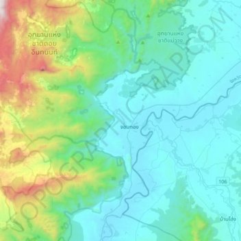
Nom : Carte topographique บ้านหลวง, altitude, relief.
Lieu : บ้านหลวง, Provinz Chiang Mai, Thailand (18.27031 98.50496 18.59031 98.82496)
Altitude moyenne : 631 m
Altitude minimum : 264 m
Altitude maximum : 2 318 m
Autres cartes topographiques
Cliquez sur une carte pour visualiser sa topographie, son altitude et son relief.
ท่าศาลา
ท่าศาลา, ต้นเปา, อำเภอสารภี, Provinz Chiang Mai, 50140, Thailand
Altitude moyenne : 304 m
อ่างข่าง
Thailand > Provinz Chiang Mai > อ่างข่าง
อ่างข่าง, Provinz Chiang Mai, Thailand
Altitude moyenne : 1 533 m